1/5


Hiking Slovakia - Tourist Map
1K+Downloads
31MBGröße
3.0.10(26-03-2022)Letzte Version

DetailsBewertungenVersionenInfo
1/5
Beschreibung von Hiking Slovakia - Tourist Map
Wander-App für das Gebiet der Slowakei. Ein Muss für jeden Wanderer.
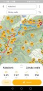
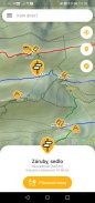
• Alle markierten Wanderwege und Abzweigungen
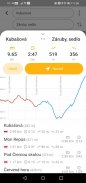
• Routenplaner mit Höhenprofil und Reiseverlauf
• Große Datenbank mit Gipfeln, Aussichtspunkten, Picknick- oder Campingplätzen, Burgen, Höhlen, Wasserquellen, Schutzhütten oder Unterkünften
• Höhen- und Höhenkarten mit Maßstab
• Möglichkeit, Karten auf das Telefon herunterzuladen und offline zu verwenden
• Anzeige des aktuellen Standorts
• Suchen Sie unter den Wegweisern und anderen Sehenswürdigkeiten
• Bergketten sehen, wenn herausgezoomt
• Kompass
Achtung: Wenn du gerne verloren bist, Adrenalin und Überleben liebst, hol dir diese App nicht... ;-)
Die Anwendung verwendet frei verfügbare Daten von freemap.sk und openstreetmap.org
Hiking Slovakia - Tourist Map – Version 3.0.10
(26-03-2022)Was ist neuFixed missing map tiles on old AndroidsFixed importing POIs and routes on low-memory phones

Hiking Slovakia - Tourist Map – APK Informationen
APK Version: 3.0.10Paket: sk.archae.hiking.androidName: Hiking Slovakia - Tourist MapGröße: 31 MBDownloads: 32Version : 3.0.10Erscheinungsdatum: 2024-05-30 19:20:49Min. Bildschirmgröße: SMALLUnterstützte CPU:
Paket-ID: sk.archae.hiking.androidSHA1 Signatur: 4E:C3:1D:BD:EA:B8:A0:08:D0:C3:F7:C9:84:A4:27:21:E2:DA:1A:8DEntwickler (CN): Organisation (O): GeoEmpiresOrt (L): BratislavaLand (C): SKBundesland/Stadt (ST): Paket-ID: sk.archae.hiking.androidSHA1 Signatur: 4E:C3:1D:BD:EA:B8:A0:08:D0:C3:F7:C9:84:A4:27:21:E2:DA:1A:8DEntwickler (CN): Organisation (O): GeoEmpiresOrt (L): BratislavaLand (C): SKBundesland/Stadt (ST):
Neueste Version von Hiking Slovakia - Tourist Map
3.0.10
26/3/202232 Downloads16.5 MB Größe
Weitere Versionen
3.0.9
26/3/202232 Downloads16.5 MB Größe
2.3
27/1/202132 Downloads4.5 MB Größe
2.2
14/1/202132 Downloads4.5 MB Größe
2.1
21/11/202032 Downloads4.5 MB Größe
2.0
17/11/202032 Downloads4.5 MB Größe
1.8
3/3/202032 Downloads4.5 MB Größe
1.7.4
13/12/202232 Downloads6.5 MB Größe
1.6
25/8/201732 Downloads5.5 MB Größe


Age of Apes 3.55
3.55
3.55Apps in derselben Kategorie

Das könnte dir auch gefallen...

English


